|
|
Name on the Register
|
Image
|
Date listed
|
Location
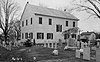
| City or town |
Description
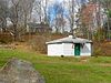
|
| 1
|
Ashley Planes
|
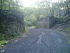 Ashley Planes Ashley Planes
|
January 25, 1980
(#80003562)
|
Off Pennsylvania Route 309
41°11′26″N 75°54′37″W / 41.190556°N 75.910278°W / 41.190556; -75.910278 (Ashley Planes)
| Fairview and Hanover Townships |
|
| 2
|
Bear Creek Village Historic District
|
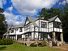 Bear Creek Village Historic District Bear Creek Village Historic District
|
October 28, 1999
(#99001287)
|
Pennsylvania Route 115 at Bear Creek Dam
41°11′00″N 75°45′20″W / 41.183333°N 75.755556°W / 41.183333; -75.755556 (Bear Creek Village Historic District)
| Bear Creek Village |
|
| 3
|
Bell Telephone Company of Pennsylvania – Wilkes-Barre Central Office
|
|
May 9, 2024
(#100010258)
|
33 E. Northampton Street
41°14′36″N 75°53′03″W / 41.2434°N 75.8841°W / 41.2434; -75.8841 (Bell Telephone Company of Pennsylvania – Wilkes-Barre Central Office)
| Wilkes-Barre |
|
| 4
|
Bittenbender Covered Bridge
|
 Bittenbender Covered Bridge Bittenbender Covered Bridge
|
December 1, 1980
(#80003563)
|
South of Huntington Mills off Legislative Route 40076
41°10′51″N 76°13′30″W / 41.180833°N 76.225°W / 41.180833; -76.225 (Bittenbender Covered Bridge)
| Huntington Township |
Collapsed in 2006
|
| 5
|
Bridge in City of Wilkes-Barre
|
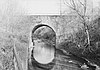 Bridge in City of Wilkes-Barre Bridge in City of Wilkes-Barre
|
June 22, 1988
(#88000828)
|
Legislative Route 5 over Mill Creek
41°15′36″N 75°52′02″W / 41.26°N 75.867222°W / 41.26; -75.867222 (Bridge in City of Wilkes-Barre)
| Wilkes-Barre |
|
| 6
|
Catlin Hall, Wilkes College
|
 Catlin Hall, Wilkes College Catlin Hall, Wilkes College
|
March 16, 1972
(#72001132)
|
92 South River Street
41°14′48″N 75°53′12″W / 41.246667°N 75.886667°W / 41.246667; -75.886667 (Catlin Hall, Wilkes College)
| Wilkes-Barre |
|
| 7
|
Central Railroad of New Jersey Station
|
 Central Railroad of New Jersey Station Central Railroad of New Jersey Station
|
May 12, 1975
(#75001652)
|
31–35 South Baltimore Street
41°14′31″N 75°52′47″W / 41.241944°N 75.879722°W / 41.241944; -75.879722 (Central Railroad of New Jersey Station)
| Wilkes-Barre |
|
| 8
|
Comerford Theater
|
 Comerford Theater Comerford Theater
|
December 3, 1980
(#80003564)
|
71 Public Square
41°14′41″N 75°52′55″W / 41.244722°N 75.881944°W / 41.244722; -75.881944 (Comerford Theater)
| Wilkes-Barre |
|
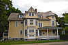
| 9
|
Denison House
|
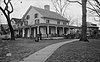 Denison House Denison House
|
December 2, 1970
(#70000550)
|
35 Denison Street
41°17′57″N 75°51′46″W / 41.299167°N 75.862778°W / 41.299167; -75.862778 (Denison House)
| Forty Fort |
|
| 10
|
Eckley Historic District
|
 Eckley Historic District Eckley Historic District
|
October 26, 1971
(#71000710)
|
Both sides of Main Street through Eckley
40°59′36″N 75°51′45″W / 40.993333°N 75.8625°W / 40.993333; -75.8625 (Eckley Historic District)
| Foster Township |
|
| 11
|
Benjamin Evans House
|
 Benjamin Evans House Benjamin Evans House
|
August 25, 1983
(#83002260)
|
Off Pennsylvania Route 93 south of Nescopeck
41°02′36″N 76°13′19″W / 41.043333°N 76.221944°W / 41.043333; -76.221944 (Benjamin Evans House)
| Nescopeck Township |
|
| 12
|
Fort Pittston School
|
|
November 21, 2022
(#100008384)
|
255 North Main St.
41°19′47″N 75°47′15″W / 41.3297°N 75.7874°W / 41.3297; -75.7874 (Fort Pittston School)
| Pittston |
|
| 13
|
Forty Fort Meetinghouse
|
 Forty Fort Meetinghouse Forty Fort Meetinghouse
|
November 3, 1988
(#88002373)
|
River Street and Wyoming Avenue
41°17′04″N 75°52′18″W / 41.284444°N 75.871667°W / 41.284444; -75.871667 (Forty Fort Meetinghouse)
| Forty Fort |
|
| 14
|
George W. Guthrie School
|
 George W. Guthrie School George W. Guthrie School
|
June 27, 1980
(#80003565)
|
643 North Washington Street
41°15′22″N 75°51′47″W / 41.256111°N 75.863056°W / 41.256111; -75.863056 (George W. Guthrie School)
| Wilkes-Barre |
|
| 15
|
Hazelton High School
|
 Hazelton High School Hazelton High School
|
April 16, 2012
(#12000222)
|
700 N. Wyoming St.
40°57′59″N 75°58′21″W / 40.966273°N 75.97263°W / 40.966273; -75.97263 (Hazelton High School)
| Hazleton |
Educational Resources of Pennsylvania Multiple Property Submission
|
| 16
|
Hotel Altamont
|
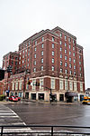 Hotel Altamont Hotel Altamont
|
December 29, 2014
(#14001101)
|
145 W. Broad St.
40°57′17″N 75°58′36″W / 40.9548°N 75.9768°W / 40.9548; -75.9768 (Hotel Altamont)
| Hazleton |
|
| 17
|
Kingston Armory
|
 Kingston Armory Kingston Armory
|
December 21, 1989
(#89002084)
|
280 Market Street
41°15′10″N 75°53′31″W / 41.252778°N 75.891944°W / 41.252778; -75.891944 (Kingston Armory)
| Kingston |
|
| 18
|
Luzerne County Courthouse
|
 Luzerne County Courthouse Luzerne County Courthouse
|
September 4, 1980
(#80003566)
|
North River Street
41°15′05″N 75°52′46″W / 41.251389°N 75.879444°W / 41.251389; -75.879444 (Luzerne County Courthouse)
| Wilkes-Barre |
|
| 19
|
Luzerne County Fresh Air Camp
|
 Luzerne County Fresh Air Camp Luzerne County Fresh Air Camp
|
February 20, 2004
(#04000064)
|
Middle Road, approximately 0.25 miles (0.40 km) northeast of the junction of Middle Road and Pennsylvania Route 3021
41°00′44″N 75°59′44″W / 41.012222°N 75.995556°W / 41.012222; -75.995556 (Luzerne County Fresh Air Camp)
| Butler Township |
|
| 20
|
Luzerne Presbyterial Institute
|
 Luzerne Presbyterial Institute Luzerne Presbyterial Institute
|
September 7, 1979
(#79002293)
|
Institute Street
41°18′39″N 75°50′29″W / 41.310833°N 75.841389°W / 41.310833; -75.841389 (Luzerne Presbyterial Institute)
| Wyoming |
|
| 21
|
Market Street Bridge
|
 Market Street Bridge Market Street Bridge
|
June 22, 1988
(#88000873)
|
Market Street/Legislative Route 11 over the Susquehanna River
41°14′55″N 75°53′07″W / 41.248611°N 75.885278°W / 41.248611; -75.885278 (Market Street Bridge)
| Kingston and Wilkes-Barre |
|
| 22
|
Markle Banking & Trust Company Building
|
 Markle Banking & Trust Company Building Markle Banking & Trust Company Building
|
March 28, 1996
(#96000322)
|
8 West Broad Street
40°57′14″N 75°58′29″W / 40.953889°N 75.974722°W / 40.953889; -75.974722 (Markle Banking & Trust Company Building)
| Hazleton |
|
| 23
|
McClintock Hall
|
 McClintock Hall McClintock Hall
|
March 16, 1972
(#72001133)
|
44 South River Street
41°14′52″N 75°53′05″W / 41.247778°N 75.884722°W / 41.247778; -75.884722 (McClintock Hall)
| Wilkes-Barre |
|
| 24
|
Memorial Presbyterian Church
|
 Memorial Presbyterian Church Memorial Presbyterian Church
|
September 18, 2017
(#100001636)
|
29 W. North Street
41°15′01″N 75°52′34″W / 41.2502°N 75.8761°W / 41.2502; -75.8761 (Memorial Presbyterian Church)
| Wilkes-Barre |
|
| 25
|
Israel Platt Pardee Mansion
|
 Israel Platt Pardee Mansion Israel Platt Pardee Mansion
|
January 12, 1984
(#84003487)
|
235 North Laurel Street and 28 Aspen Street
40°57′36″N 75°58′22″W / 40.96°N 75.972778°W / 40.96; -75.972778 (Israel Platt Pardee Mansion)
| Hazleton |
Designed by architect George Franklin Barber
|
| 26
|
River Street Historic District
|
 River Street Historic District River Street Historic District
|
September 10, 1985
(#85002328)
|
Franklin, River, West River, West Jackson, West Union, West Market, West Northampton, West South and West Ross Streets and Barnum Place
41°14′49″N 75°53′09″W / 41.246944°N 75.885833°W / 41.246944; -75.885833 (River Street Historic District)
| Wilkes-Barre |
|
| 27
|
St. Gabriel's Catholic Parish Complex
|
 St. Gabriel's Catholic Parish Complex St. Gabriel's Catholic Parish Complex
|
August 22, 2002
(#02000889)
|
122–142 South Wyoming Street
40°56′55″N 75°58′20″W / 40.948611°N 75.972222°W / 40.948611; -75.972222 (St. Gabriel's Catholic Parish Complex)
| Hazleton |
|
| 28
|
St. John the Evangelist Roman Catholic Church and School Building
|
 St. John the Evangelist Roman Catholic Church and School Building St. John the Evangelist Roman Catholic Church and School Building
|
July 30, 2003
(#03000721)
|
419 North Main Street
41°15′29″N 75°52′03″W / 41.258056°N 75.8675°W / 41.258056; -75.8675 (St. John the Evangelist Roman Catholic Church and School Building)
| Wilkes-Barre |
|
| 29
|
St. Stanislaus Institute
|
 St. Stanislaus Institute St. Stanislaus Institute
|
December 30, 2008
(#08001267)
|
141 Old Newport Street
41°11′32″N 76°01′03″W / 41.192222°N 76.0175°W / 41.192222; -76.0175 (St. Stanislaus Institute)
| Newport Township |
|
| 30
|
George W. Search House
|
 George W. Search House George W. Search House
|
July 10, 2009
(#09000387)
|
56 South Main Street
41°09′03″N 76°09′03″W / 41.150833°N 76.150833°W / 41.150833; -76.150833 (George W. Search House)
| Shickshinny |
|
| 31
|
Stegmaier Brewery
|
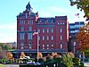 Stegmaier Brewery Stegmaier Brewery
|
May 30, 1979
(#79002292)
|
Roughly bounded by Coal, Welles, Market, Lincoln and Baltimore Streets
41°14′32″N 75°52′36″W / 41.242222°N 75.876667°W / 41.242222; -75.876667 (Stegmaier Brewery)
| Wilkes-Barre |
|
| 32
|
Stoddartsville Historic District
|
 Stoddartsville Historic District Stoddartsville Historic District
|
November 12, 1998
(#98001373)
|
South side of Pennsylvania Route 115 at the Lehigh River in Stoddartsville
41°07′47″N 75°37′42″W / 41.129806°N 75.628333°W / 41.129806; -75.628333 (Stoddartsville Historic District)
| Buck Township |
|
| 33
|
Swetland Homestead
|
 Swetland Homestead Swetland Homestead
|
December 13, 1978
(#78002427)
|
855 Wyoming Avenue
41°18′06″N 75°51′10″W / 41.301667°N 75.852778°W / 41.301667; -75.852778 (Swetland Homestead)
| Wyoming |
|
| 34
|
Weiss Hall
|
 Weiss Hall Weiss Hall
|
November 27, 1972
(#72001134)
|
98 South River Street
41°14′47″N 75°53′12″W / 41.246389°N 75.886667°W / 41.246389; -75.886667 (Weiss Hall)
| Wilkes-Barre |
|
| 35
|
West End Wheelmen's Club
|
 West End Wheelmen's Club West End Wheelmen's Club
|
May 30, 1997
(#97000521)
|
439 South Franklin Street
41°14′24″N 75°53′47″W / 41.24°N 75.896389°W / 41.24; -75.896389 (West End Wheelmen's Club)
| Wilkes-Barre |
|
| 36
|
Wilkes-Barre Silk Company Mill
|
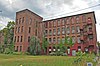 Wilkes-Barre Silk Company Mill Wilkes-Barre Silk Company Mill
|
November 25, 2019
(#100004666)
|
92 S. Empire St.
41°14′03″N 75°52′21″W / 41.2342°N 75.8726°W / 41.2342; -75.8726 (Wilkes-Barre Silk Company Mill)
| Wilkes-Barre |
|
| 37
|
Wyoming Monument
|
 Wyoming Monument Wyoming Monument
|
May 13, 2002
(#02000509)
|
U.S. Route 11, Wyoming Avenue and Susquehanna Street
41°18′13″N 75°50′45″W / 41.303611°N 75.845833°W / 41.303611; -75.845833 (Wyoming Monument)
| Wyoming |
|
| 38
|
Wyoming Seminary
|
 Wyoming Seminary Wyoming Seminary
|
August 6, 1979
(#79002291)
|
Sprague Avenue
41°15′48″N 75°53′54″W / 41.263333°N 75.898333°W / 41.263333; -75.898333 (Wyoming Seminary)
| Kingston |
|
 Location of Luzerne County in Pennsylvania


