Nes aan de Amstel
| Nes aan de Amstel | |
|---|---|
| Village | |
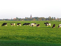
 View of Nes aan de Amstel View of Nes aan de Amstel | |
  | |
| Coordinates: 52°15′33″N 4°52′15″E / 52.25917°N 4.87083°E / 52.25917; 4.87083 | |
| Country | Netherlands |
| Province | North Holland |
| Municipality | Amstelveen |
| Area | |
| • Total | 10.39 km2 (4.01 sq mi) |
| Elevation | −0.8 m (−2.6 ft) |
| Population (2021) | |
| • Total | 985 |
| • Density | 95/km2 (250/sq mi) |
| Time zone | UTC+1 (CET) |
| • Summer (DST) | UTC+2 (CEST) |
| Postal code | 1189 |
| Dialing code | 020 |
| Website | nesaandeamstel.nl |
Nes aan de Amstel (Dutch pronunciation: ) is a village in the municipality of Amstelveen in the province of North Holland, Netherlands. The village's name indicates that it is located on the Amstel; it is situated on the edge of the Rond Hoep polder.
History
 Sint-Urbanuskerk
The village was established in the 16th century and has gradually been developing since 1947. The landscape is largely determined by the town's Catholic church, the Sint-Urbanuskerk, built to a design by the architect Joseph Cuypers.
Events
Nes aan de Amstel is known for hosting the Dorpsfeest. Each year in the summer during the town festival, the slob en sloot race is organised, during which approximately 50 participants submit an itinerary through the fields and ditches around the town.
Notable people
Notable people from Nes aan de Amstel include:
- Agatha Deken (1741–1804), writer and poet
References
- ^ a b c "Kerncijfers wijken en buurten 2021". Central Bureau of Statistics. Retrieved 28 April 2022.
- ^ "Postcodetool for 1189VK". Actueel Hoogtebestand Nederland (in Dutch). Het Waterschapshuis. Retrieved 28 April 2022.
External links
 Media related to Nes aan de Amstel at Wikimedia Commons
- Official site (in Dutch)