Tidewater Lock
Today, Tidewater Lock is a topic that has gained relevance in different areas of society. Its impact extends from the personal to the professional sphere, generating discussions and reflections on its influence on our lives. From its origins to its current evolution, Tidewater Lock has been the object of interest and study, motivating experts and fans to delve into its many facets. In this article, we will explore the different perspectives and aspects related to Tidewater Lock, analyzing its importance and implications in today's world.
| Tidewater Lock | |
|---|---|
 | |
 | |
| 38°54′00″N 77°03′28″W / 38.8999°N 77.0578°W | |
| Waterway | Chesapeake and Ohio Canal |
| Country | USA |
| State | Washington, D.C. |
| Operation | Defunct |
| Length | 54 m |
| Width | 4 m |
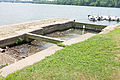
The Tidewater Lock is a dam[1] in Washington, D.C. to the west of the mouth of Rock Creek at the Potomac River, on the east side of Georgetown. Built to connect the Chesapeake and Ohio Canal, opened in 1831, with the Potomac, it was a busy maritime intersection during several decades of the canal's heyday. C&O documents refer to it variously as Lock 0 and Tide Lock A.
Canal documents sometimes list a "Tide Lock B" on section "I" which stood at the lockhouse at 17th and Constitution Ave NW. It was completed in 1834.[2]
Today, the lock marks Milestone 0 of the National Park Service's Chesapeake & Ohio Canal trail.[3]
Gallery
-
 View of downstream gate pocket where the canal joins the Potomac River
 -
 Ruins of the waste weir, which adjoins the Tidewater lock
 -
 Tidewater lock, with the Watergate complex in the background
_gate_pocket_detail.jpg)
_at_end_of_Chesapeake_and_Ohio_Canal.jpg)

See also
References
- ^ "Tidewater Lock". Geographic Names Information System. United States Geological Survey. Retrieved January 26, 2014.
- ^ Unrau, Harlan D. (2007). Historic Resource Study: Chesapeake & Ohio Canal (PDF). Hagerstown, Md.: U.S. Department of the Interior, National Park Service, Chesapeake & Ohio Canal National Historical Park. p. 213. LCCN 2007473571.
- ^ "C&O Canal Maps". Chesapeake & Ohio Canal. National Park Service. Retrieved October 30, 2016.