Maulévrier-Sainte-Gertrude
In today's world, Maulévrier-Sainte-Gertrude is a topic that continues to generate interest and debate. Whether due to its impact on society, its relevance in popular culture or its importance in the scientific field, Maulévrier-Sainte-Gertrude continues to be the object of study and analysis around the world. From its origins to its influence today, Maulévrier-Sainte-Gertrude has left an indelible mark on history and its relevance continues today. In this article we will address different aspects related to Maulévrier-Sainte-Gertrude, exploring its different facets and its impact on the contemporary world.
Maulévrier-Sainte-Gertrude | |
|---|---|
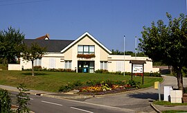
 The town hall in Maulévrier-Sainte-Gertrude | |
| Coordinates: 49°33′20″N 0°43′18″E / 49.5556°N 0.7217°E | |
| Country | France |
| Region | Normandy |
| Department | Seine-Maritime |
| Arrondissement | Rouen |
| Canton | Port-Jérôme-sur-Seine |
| Intercommunality | Caux Seine Agglo |
| Government | |
| • Mayor (2020–2026) | David Malandain[1] |
Area 1 | 14.16 km2 (5.47 sq mi) |
| Population (2022)[2] | 1,052 |
| • Density | 74/km2 (190/sq mi) |
| Time zone | UTC+01:00 (CET) |
| • Summer (DST) | UTC+02:00 (CEST) |
| INSEE/Postal code | 76418 /76490 |
| Elevation | 7–144 m (23–472 ft) (avg. 120 m or 390 ft) |
| 1 French Land Register data, which excludes lakes, ponds, glaciers > 1 km2 (0.386 sq mi or 247 acres) and river estuaries. | |
Maulévrier-Sainte-Gertrude (French pronunciation: [molevʁije sɛ̃t ʒɛʁtʁyd]) is a commune in the Seine-Maritime department in the Normandy region in northern France.
Geography
A farming village situated in the Pays de Caux, it is located some 24 miles (39 km) northwest of Rouen at the junction of the D40 and D281 and also the D131 and D490 roads.
Heraldry
 |
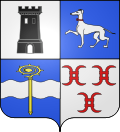
The arms of Maulévrier-Sainte-Gertrude are blazoned : Quarterly 1: Argent, a tower sable open and pierced of the field; 2: Azure, a greyhound argent, collared gules; 3: Azure, a fess wavy argent, overall a crozier Or palewise; 4: Argent 3 millrinds gules.
|
Population
| Year | Pop. | ±% p.a. |
|---|---|---|
| 1968 | 621 | — |
| 1975 | 685 | +1.41% |
| 1982 | 905 | +4.06% |
| 1990 | 922 | +0.23% |
| 1999 | 905 | −0.21% |
| 2007 | 912 | +0.10% |
| 2012 | 985 | +1.55% |
| 2017 | 987 | +0.04% |
| Source: INSEE[3] | ||
Places of interest
- The church of St. Gertrude, dating from the sixteenth century.
- The church of St.Léonard, dating from the eleventh century.
- The thirteenth century donjon.
- Traces of another feudal castle. [citation needed]
See also
References
- ^ Liste des maires du département de la Seine-Maritime, 10 August 2020
- ^ "Populations de référence 2022" (in French). The National Institute of Statistics and Economic Studies. 19 December 2024.
- ^ Population en historique depuis 1968, INSEE
External links
- Official website of Maulévrier-Sainte-Gertrude (in French)


